Photo by Philip Hargrove for Cornerstone Mansion · February 25, 2026
The notion of "historic ruins" in the United States often conjures images of crumbling colonial forts or perhaps the adobe remnants of ancient Pueblo cliff dwellings. Yet, the reality of our nation's most vulnerable historical sites is far more diverse, far more challenging, and frankly, far more compelling than most travel brochures would have you believe. I’ve spent years poking around forgotten corners, brushing off dust, and trying to understand the whispers of the past, and I can tell you this much: our history isn't just written in monuments, it's etched into the very landscapes now eroding before our eyes.
What’s truly fascinating is how these places, from ancient settlements to Cold War outposts, are facing a modern existential threat: climate change. The good news? A groundbreaking initiative is underway to not only preserve these treasures but to transform how we experience them. This isn't about perfectly restoring a facade; it's about acknowledging decay as part of the story, then using technology to peel back the layers of time.
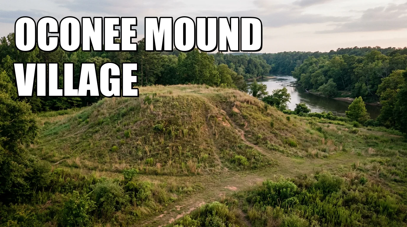
Echoes from the Floodplain: Unearthing Oconee Mound Village
Imagine standing in a vast river basin, the air thick with the scent of damp earth, and trying to picture a bustling community that thrived here a thousand years ago. That’s the challenge, and the magic, of visiting the Oconee Mound Village in the Southeast. This isn't some well-defined colonial outpost; it’s a mid-second millennium CE indigenous earthwork village, a sprawling network of low adobe dwellings and ceremonial mound platforms that once pulsed with life along the Oconee River floodplain. Most guides might gloss over sites like this, dismissing them as "mere mounds," but missing the profound cultural narratives embedded within their subtle contours.
For centuries, this village endured the natural rhythms of the river. Now, however, seasonal rainfall intensity has risen 20% since 2010, according to recent data. This isn't just a minor nuisance; it's a destructive force causing severe bank undercutting and irreversible loss of the very earthen embankments that define the site. A typical visit might leave you wondering where the actual village stood, frustrated by the lack of visible structures. Yet, that initial confusion underscores the urgency of its preservation. To counter this relentless erosion, the preservationists are deploying ingenious hydrological management techniques, installing permeable, vegetated bio-berms along critical riverbanks. These aren't ugly concrete walls; think living barriers designed to reduce peak flow velocity and trap sediment, effectively rebuilding the riverbanks naturally. Additionally, the mounds themselves are being reinforced with geotextile liners—a permeable fabric—covered by native grasses, preventing wash-outs while maintaining their archaeological integrity. They’re even tracking groundwater fluctuations with solar-powered sensors, which will trigger temporary visitor closures when flood thresholds are reached.
Here’s where it gets truly transformative: the augmented reality (AR) experience. Visitors, often equipped with park-issued tablets, can activate geolocated AR overlays that rebuild those vanished adobe huts and wooden palisade walls right before your eyes. You’re not just looking at a flat field; you’re seeing homes, defensive structures, and ceremonial spaces rise holographically from their hidden foundations. Tapping individual structures reveals 3D holographic avatars—a potter shaping clay, a farmer tending maize, dancers engaged in ceremony. It's an immersive historical reconstruction, far more visceral than any static sign. Furthermore, an innovative flood-simulation module projects historical flood events, allowing you to witness the very challenges the original inhabitants faced, and how they adapted to their environment. It’s a profound lesson in resilience, delivered not as a lecture, but as a living, breathing history lesson.
Where Iron Giants Once Roared: The Gritty Persistence of Monroe Steelworks
Stepping into the Monroe Steelworks along the Mahoning River corridor feels like entering a forgotten monument to American ingenuity, one that’s been chewed up and spit out by time. Established in 1873, this iron-forging facility was a titan of industry, its blast furnaces and boiler houses once dominating the landscape. Today, it’s a skeletal remains of that power, a breathtaking, if slightly unsettling, testament to the Rust Belt's industrial might. Unlike the clean, sanitized museums of industry, Monroe is raw, exposed, and deeply melancholic. You'll find yourself amidst crumbling brickwork and rusting iron, feeling the sheer scale of the labor that once defined these spaces.
The elements, however, are unforgiving. This area faces intensified freeze-thaw cycles—winter thaws followed by sudden, brutal freezes—that accelerate masonry cracking, slowly but surely dismantling the very bones of these colossal structures. Spring floods, too, are a recurring menace, eroding the foundation soils that have supported these giants for over a century. A common misconception is that these old industrial sites are "indestructible." Monroe proves that even iron can be brought low by persistent environmental assault. To stabilize these giants, preservationists are applying breathable sacrificial lime-based mortar repointing to mortar joints. This isn’t a quick fix; it’s a meticulous process designed to reduce water ingress without trapping moisture, allowing the old structures to breathe. Foundation underpinning, using mini-piles and micropiles, is subtly stabilizing key furnace walls, a delicate operation designed to minimize invasive excavation while preserving the subsurface industrial artifacts. Riverbanks are also getting a facelift with living shoreline terraces, constructed with coir logs and native wetland plantings, engineered to dissipate flood energy naturally.
What surprised me most here was the sheer ambition of the AR interpretation. Forget passive observation. Through AR goggles stationed at furnace platforms, visitors witness a mesmerizing time-lapse reconstruction: the erection of smokestacks, the placement of pig iron ingots, all in an accelerated sequence that makes the colossal scale of the original construction palpable. Then, it goes a step further. Interactive workstations transport you into the role of a steelworker. Virtual supervisors beckon you to "operate" bellows via motion-capture gloves, experiencing the intense heat and deafening sound of a working forge—a truly visceral plunge into a bygone era. Perhaps most intriguing, real-time structural health data streams, visible in AR as colored stress maps, highlight areas under active conservation monitoring. This detail isn’t just cool tech; it underscores the ongoing, dynamic battle for preservation, turning visitors into witnesses of the fight itself.
Beneath the Pines: Unlocking the Cold War Secrets of Camp Cascade
Venturing into Camp Cascade in the Pacific Northwest feels like stumbling upon a secret. Nestled on a forested ridge high above the dramatic Cascade River Gorge, this 1950s radar station is a relic of a different kind: a monument to the Cold War’s quiet vigilance. Here, concrete bunkers and antenna mounts slowly succumb to the relentless embrace of the forest. Unlike other ruins, where decay hints at ancient lives or industrial might, Camp Cascade’s overgrown structures evoke a sense of unease, a lingering echo of global tension. Most guides focus on picturesque landscapes in the Pacific Northwest; they rarely delve into the stark, utilitarian beauty of its military past.
The dominant threat here is fire, a pervasive and growing danger in the region. Longer dry seasons have caused wildfire frequency to increase by 30%, and invasive understory vegetation not only hampers access but accelerates structural decay. It’s a battle between human legacy and nature's reclaiming force, intensified by a changing climate. To combat this, a critical preservation strategy involves defensible space management. This isn’t just hacking away at bushes; it's about creating five-meter-wide cleared buffer zones around structures, using controlled grazing and selective underbrush thinning to reduce fire fuel loads in a sustainable, ecological manner. The concrete bunker exteriors are even being treated with intumescent paints—special coatings that swell under heat, protecting the irreplaceable interior artifacts during a wildfire. Monitoring, too, has gone high-tech: autonomous UAVs (drones) equipped with multispectral sensors map undergrowth density and detect hotspots, enabling preemptive thinning before a blaze can even ignite.
What secrets lie within these bunkers? The AR experience peels back the decades. Visitors, wearing AR headsets, witness rotating radar dishes magically superimposed atop their existing concrete bases, complete with animated signal-beam projections sweeping the horizon. It's a striking visual that brings the station's original purpose into sharp focus. Perhaps even more engaging are the "Mission Brief Modules." Holographic officers deliver declassified Cold War scenarios, guiding visitors through tense decision-making simulations at interactive radio-operator consoles. You’re not just seeing history; you’re participating in it, understanding the weight of the decisions made here. And in a stark reminder of the ever-present threat of nature, a safe AR zone allows visitors to trigger virtual ember showers and watch protective measures, like fire sprinkler activation, in real time. It’s a sobering, yet profoundly educational, demonstration of both past and present dangers.
The Unseen Architects: Blending Tech, Community, and Vigilance
These aren't just isolated preservation efforts; they're part of an integrated, forward-thinking initiative that understands history isn't static. It's a dynamic interplay between the past, the present, and a very uncertain future. A robust Wi-Fi mesh network is being deployed across each site, ensuring seamless AR content delivery, a crucial detail often overlooked in grand plans. Visitors can expect to find multilingual AR tablets and lendable headsets readily available at visitor centers, making these cutting-edge experiences accessible to everyone, not just those with the latest tech.
But this isn't solely about gizmos and gadgets. Crucially, the initiative recognizes that true preservation extends beyond brick and mortar, or adobe and earth. For Oconee Mound Village, partnerships with descendant communities are central to cultural content validation, ensuring the AR experiences respectfully and accurately reflect indigenous history. At Monroe Steelworks, collaboration with local unions and heritage foundations supports programming, bridging the gap between historical industry and contemporary community pride. And at Camp Cascade, coordinating with state fire agencies for managed buffer-zone planning is vital, integrating preservation with essential environmental management. These are the unsung heroes of heritage work: the community members, the specialists, the quiet champions who often go unmentioned in typical travel guides.
This is also a living experiment, driven by constant observation. A centralized dashboard integrates hydrological, structural, and ecological sensor feeds from all three sites. This isn't just data collection for its own sake; it means annual climate-vulnerability assessments are conducted to recalibrate preservation tactics, adapting to real-world changes. Furthermore, visitor feedback, solicited through embedded AR surveys, continuously refines interpretive content, ensuring the experiences remain engaging and relevant. It’s an adaptive, iterative approach, a refreshing departure from the rigid, one-size-fits-all preservation models of the past.
Charting Your Journey to These Unsung Corners of History
So, how does one embark on a journey to these extraordinary, yet vulnerable, sites? First, manage your expectations: these are not manicured tourist attractions. They are active preservation zones, laboratories of history. Admission fees will likely align with typical national or state park fees, so expect a nominal cost of entry, perhaps a few dollars per vehicle or per person. Parking, while generally available, might be limited at certain times, especially if visitor numbers surge with the introduction of these new AR experiences.
When planning your visit, timing is everything. For Oconee Mound Village, I’d suggest avoiding peak rainy seasons in late spring and early fall, when river levels are highest and temporary closures are more likely. The summer months, though hot, often offer more stable conditions. At Monroe Steelworks, the biting winds of winter can be brutal, and while the freeze-thaw cycle is a threat, it makes for a stark, dramatic landscape. Late spring and early fall offer the most comfortable weather for exploring the vast industrial complex. For Camp Cascade, given the wildfire risks, late spring after the snowmelt but before the intense dry heat of summer, or early fall after the first rains, would be ideal. Always check park websites for current conditions, especially regarding weather advisories or potential closures due to climate-related events.
Expect to spend at least half a day at each location, more if you truly want to immerse yourself in the AR experiences and ponder the narratives. These are places for reflection, for understanding the challenges faced by past inhabitants and present-day preservationists alike. Don't rush. The tablet-based AR experiences are intuitive, but they invite interaction, requiring you to pause, look, and engage. This isn't just about seeing; it's about connecting with history on a deeper, more personal level. You’ll leave not just with photographs, but with a profound appreciation for the resilience of both human heritage and the dedicated individuals fighting to protect it.
Ultimately, these climate-threatened ruins represent a new frontier in historical interpretation. By pairing site-specific conservation with immersive AR reconstruction, we're not just safeguarding fragile structures; we're transforming passive observation into engaging, educational exploration. These hidden historic gems aren't just surviving; they're evolving, telling their stories with renewed urgency and breathtaking clarity, ensuring their whispers echo for generations to come. Go see them. Understand them. Be part of their future.
Historic Mansions Worth Building a Weekend Around
Start with the estates and mansion properties that still justify tickets, routing, and a real visit, not just a mood-board detour.
Uncovering America’s Ancient Stones: Your Historic Ruins FAQ
Are historic ruins free to visit?
Entrance fees vary by site and managing agency; some local or state ruins are free, while national park–managed ruins generally charge per-vehicle or per-person fees.
Does it cost money to see the Tulum ruins?
Yes; the Instituto Nacional de Antropología e Historia (INAH) charges approximately 85 MXN (about $5 USD) for adult admission.
Do you have to pay to see the Mayan ruins?
Yes; most major Mayan archaeological zones in Mexico require an INAH ticket, typically around 80–100 MXN per adult.
How much is the Chichen Itza entrance fee?
As of 2025, foreign adults pay $29 USD plus a 10 MXN local preservation fee; Mexican residents pay a lower rate set in pesos.
How much does it cost to go to Devils Tower?
Devils Tower National Monument charges a $25 per-vehicle entrance fee valid for seven days, or $15 per person if entering on foot, bicycle, or motorcycle.
Can you see Devils Tower without paying?
You can view Devils Tower from outside the monument boundary without a fee, but accessing the formal trails and picnic grounds requires the entrance pass.
What movie was filmed at Devils Tower?
Steven Spielberg’s 1977 classic Close Encounters of the Third Kind featured Devils Tower as a central filming location.
Does anything live on top of Devils Tower?
Birds such as cliff swallows and peregrine falcons nest in crevices atop the tower, alongside lichens and insects, but no large mammals inhabit the summit.
How realistic is Close Encounters?
While the film’s depiction of alien visitation is fictional, its portrayal of human reactions and the monument’s landscape is true to life.
Is there anything to do around Devils Tower?
Visitors can enjoy five miles of maintained hiking trails, ranger-led programs, picnic areas, and guided rock-climbing experiences.
What is the best time of year to visit historic ruins in the U.S.?
Spring (April–June) and fall (September–October) offer mild temperatures and fewer crowds at most ruin sites.
Which U.S. historic ruins are most popular?
Mesa Verde’s cliff dwellings in Colorado and Chaco Canyon in New Mexico consistently draw the highest visitation.
Are guided tours available at U.S. ruin sites?
Yes; many national and state parks offer ranger-led and private guided tours year-round, often requiring advance reservations.
What should I pack when visiting outdoor ruins?
Bring sturdy shoes, plenty of water, sun protection, layered clothing for temperature changes, and a camera for documentation.
Are there accessibility options at major ruin sites?
Most national-park ruins provide accessible parking, paved viewpoints, and shuttle services; however, trail access may be limited.
Why This Page Exists
Maison builds place guides to help readers plan a real visit or understand a real site. When a page makes present-day access, booking, or visitor claims, those details are revised against public-facing source material and editorial review. For the wider standards behind that work, see methodology.
The Cornerstone Brief
One historic place, once a week — what it is, why it matters, whether it's worth going. No filler, no paid placements.
Coming soon. Unsubscribe any time.
We use cookies to enhance your experience. By continuing to visit this site you agree to our use of cookies.