What This Article Is Actually Measuring
This Maison-built 2026 matrix tracks how public stewards are now making triage decisions about threatened historic sites: where they still try to hold the line, where they move infrastructure or entire assets, and where they accept that preservation in place is no longer realistic and shift to documentation before loss.
"Preservation" is still the wrong mental model for a lot of readers. The older idea assumes that enough money, enough engineering, or enough moral will can keep every important place intact where it stands. The federal record now shows something harsher and more useful. At some sites, managers are reinforcing shorelines and repairing masonry. At others, they are moving lighthouses, shifting visitor facilities inland, or documenting archaeological landscapes that are expected to disappear anyway.
Maison reviewed a compact source base for this article on May 18, 2026: current National Park Service climate strategy pages, case studies on threatened historic resources, and public material on archaeological mitigation in actively shrinking coastal landscapes. The aim is to map how climate pressure is changing the way public history is managed.
Maison rule for this matrix
A threatened place does not automatically count as a triage case. It enters the matrix only when the public record shows a management response that reveals the site's real climate future: shoreline intervention, relocation, facility retreat, or formal mitigation work because the site cannot be saved in place.
That rule strips away a lot of sentimental noise. Once a site moves from "we hope to preserve this" to "we are actively deciding what kind of loss we can still manage," the story becomes much sharper and much more useful.
The Maison Triage Model
The first Maison Historic-Site Triage Matrix uses a 10-point scale. It does not measure beauty, age, or symbolic prestige. It measures how deeply climate pressure has already forced managers to change what preservation means.
| Matrix Level | Score Range | What Maison Is Seeing |
|---|---|---|
| Watch And Stabilize | 1-3 | The site is threatened, but the dominant public response is still monitoring, routine repair, or early stabilization. |
| Selective Fortification | 4-6 | Managers are actively defending key resources with repairs, shoreline work, or structural investment while acknowledging long-term risk. |
| Retreat / Relocation | 7-8 | The climate threat is strong enough that assets, facilities, or access patterns are being moved rather than merely reinforced. |
| Managed Loss | 9-10 | Managers are prioritizing documentation, mitigation, or knowledge capture because the place itself is expected to keep disappearing. |
The important thing about this scale is that it treats retreat and documentation as management outcomes, not as admissions of incompetence. In climate-exposed heritage work, a move inland can be evidence of realism, and a mitigation project can be evidence of seriousness rather than surrender.
The Maison Historic-Site Triage Matrix 2026
The first Maison pass focuses on five high-signal case studies that together reveal the new preservation logic. Scores are Maison's interpretation of public evidence as of May 18, 2026.
Maison Historic-Site Triage Matrix 2026: first-pass scores
| Case Study | Maison Score | Climate Pressure | What Managers Are Actually Doing |
|---|---|---|---|
| MRDAM Louisiana delta archaeological sites | 10/10 | Accelerating land loss, water intrusion, and the expectation that many sites will not remain physically intact. | Shift from preservation in place to mitigation, documentation, and capture of cultural and ecological knowledge before further loss. |
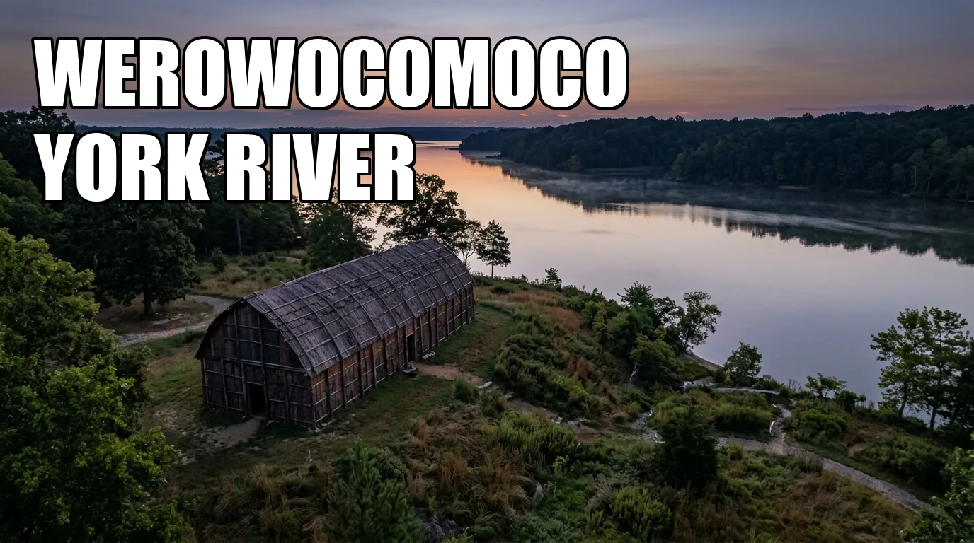
| Werowocomoco Virginia shoreline | 9/10 | Ongoing shoreline erosion and tidal pressure on an Indigenous center of power tied to the Chesapeake. | Install living-shoreline defenses and stabilize edges while acknowledging that damage has already occurred. |
| Assateague visitor facilities Maryland and Virginia | 8/10 | Storm exposure, erosion, and the high cost of defending low-lying access infrastructure forever. | Relocate vulnerable facilities and rethink where the public can be served safely over time. |
| Cape Hatteras Lighthouse North Carolina | 7/10 | Severe shoreline retreat made continued in-place defense unrealistic. | Move the asset inland rather than keep losing ground to the Atlantic. |
| Fort Jefferson Dry Tortugas National Park, Florida | 6/10 | Sea-level rise, storms, and growing stress on a major masonry fort in a marine environment. | Make strategic repairs and prioritize investment where climate pressure most directly threatens the historic structure. |
The scores tell a simple story. The farther a place moves from in-place preservation and toward relocation or documentation-before-loss, the more the old heritage script breaks down. That is why the Louisiana mitigation work sits at the top of the matrix. It is the least sentimental and therefore the most honest.
How To Read The 120-Plus Unit Warning
The Park Service's warning that more than 120 coastal and Great Lakes units face climate pressure is easy to misunderstand. The number does not mean every park is in immediate catastrophe mode or that every site will require the same response. It means climate pressure is no longer a niche management problem affecting a few unusually exposed places. It is now a system condition across a large public-history portfolio.
That matters because once a threat becomes systemic, preservation culture has to change with it. Managers can no longer treat each threatened shoreline, fort, visitor center, or archaeological edge as a one-off emergency solved by local ingenuity alone. They need repeatable triage logic. That is exactly what the current case studies begin to reveal.
| What The Big Number Does Not Mean | What It Actually Signals |
|---|---|
| Not every site is about to vanish tomorrow. | Many sites still have time, but that time is now part of active planning rather than passive hope. |
| Not every response will be a seawall or major rebuild. | The response menu now includes softer shoreline work, facility retreat, relocation, and mitigation-only strategies. |
| Not every loss will be visually dramatic at first glance. | Some of the first changes appear in access routes, staffing priorities, seasonal operations, and quiet documentation work. |
| Not every "saved" site is truly secure. | A successful intervention may only buy a different timeline, not permanent safety. |
That table is why this subject deserves wider pickup. The climate story is procedural as well as visual, revealing how a national steward decides which places still justify heavy defense, which ones can be moved, and which ones must be studied before the landscape itself erases the evidence.
Fortify Is Not Victory
A lot of public coverage still treats shoreline stabilization or historic-structure repair as proof that a threatened site has been "saved." That is too neat. The Park Service's own case material points to something more sober. Fortification is a management choice made under worsening conditions, not a guarantee that the site has been pulled out of danger.
Werowocomoco is the clearest example. The site matters because it was not a minor outpost. It was a center of political and ceremonial life along the York River, central to the early contact story between Powhatan peoples and the English. By the time the Park Service was publicly describing the climate problem there, the erosion was already legible in painfully physical terms: shoreline loss, trees hanging near the edge, and the sense that archaeological ground was being peeled away in pieces.
The living-shoreline response is serious and worth studying. It uses grasses, stone, and softer edge-building strategies to absorb wave energy and help soil hold where harder engineering might fail or distort the landscape. But the existence of that intervention is not comforting. It is diagnostic. It tells readers that managers no longer believe passive monitoring is enough.
Fort Jefferson makes the same point in a different visual register. The fort is massive, photogenic, and seemingly permanent. That can fool visitors into thinking time works in masonry's favor. It does not. Once sea-level rise and stronger storm patterns become part of the capital-planning conversation, the fort stops being a stable inheritance and starts being a resource triage problem with very expensive walls.
That is why Fort Jefferson scores as a selective-fortification case rather than as a success story. Strategic repair is a rational move. It is also a public admission that climate pressure is now inside the preservation budget, the maintenance plan, and the long-term visitor promise.
Retreat Is Not Defeat
If fortification is easy for the public to romanticize, retreat is easy for the public to misunderstand. Moving a lighthouse or shifting visitor facilities inland can sound like failure if the only acceptable preservation outcome is "keep everything exactly where it is." The climate record makes that standard unusable.
Cape Hatteras is the American precedent everyone should know because it demonstrates the logic in a single image. A lighthouse is supposed to look immovable. Yet the smarter move was to relocate it rather than treat erosion as a temporary inconvenience. The site did not lose its importance because it moved. It kept its importance because it moved before the sea made the decision on its own.
Assateague extends the same lesson from iconic asset to everyday visitor infrastructure. This is where the triage story becomes more relatable to the average traveler. A visitor center, parking area, road segment, or public-service node may not sound as dramatic as a lighthouse, but it decides whether people can still access a place safely and affordably. When those facilities are relocated, managers are admitting that old access patterns are part of the vulnerability map too.
That is a subtle but important shift in public history. The object being preserved is no longer only the landmark. It is also the possibility of future visitation. If the only way to keep a park visit viable is to move the support system, then retreat becomes part of preservation rather than its opposite.
How the five first-pass cases break across Maison's response modes
The chart warns against simplistic hero narratives. Most high-signal climate heritage work is no longer about a clean save. It is about choosing which kind of compromise produces the least cultural loss and the most durable access.
Documentation Is Not A Consolation Prize
The most important section of the matrix is also the hardest one to sell emotionally. People like the idea of rescue. They like stabilization projects, new seawalls, moved lighthouses, and dramatic engineering. Documentation sounds weaker because it is easier to confuse with surrender. In the Louisiana delta, it is something else: a recognition that disappearing landscapes still contain history worth capturing before the ground itself is gone.
The Mississippi River Delta Archeological Mitigation Project, or MRDAM, is the case that forces the vocabulary change. Once a coastline is shrinking fast enough, some archaeological sites are no longer candidates for permanent rescue. The serious work becomes mitigation: recording what can still be learned, collecting environmental and cultural knowledge, and making sure future generations inherit more than a line in a database saying a place used to exist here.
That is why MRDAM receives the top score in this first Maison matrix. It is the most advanced case of climate realism in the source set. It does not pretend the old preservation promise still holds. It asks what can be saved once the place itself can no longer be guaranteed. That is a harder question and a much more useful one.
It also shifts the story from architecture alone to communities, memory, and justice. When low-lying cultural landscapes disappear, the loss is not only archaeological. It affects people whose stories are rooted in those landscapes, including communities whose heritage has already been under-documented. In that sense, mitigation is not a lesser form of preservation. It is often the last serious form of preservation still available.
The New Preservation Script
The climate triage story becomes much easier to grasp once the old preservation script is placed next to the new one. A lot of confusion comes from using yesterday's expectations to judge today's decisions.
| Old Heritage Assumption | What The Current Climate Record Shows Instead | Visitor-Level Meaning |
|---|---|---|
| An important site should stay where it is. | Sometimes the most responsible choice is relocation before catastrophic loss. | The place remains meaningful even if the physical setup changes. |
| Repair means the danger is under control. | Repair may only buy time inside a worsening climate regime. | A preserved facade can still sit inside an unstable future. |
| Documentation happens after preservation. | At some sites, documentation is the preservation strategy that remains. | The archive may become the last durable form of access. |
| Visitor infrastructure is secondary to the landmark itself. | Roads, parking, visitor centers, and service nodes are now part of the climate vulnerability map. | How people reach a site can change before the landmark itself disappears. |
This table makes the piece broader than a single coastline story. It applies to forts, lighthouses, Indigenous landscapes, battlefield edges, and low-lying archaeological zones all over the country. The names will differ, but the management logic will not.
What Visitors Miss When They Use The Word "Saved"
Visitors understandably want clean endings. A site was threatened, funding arrived, repairs happened, and the site was saved. That is the emotional grammar most heritage coverage still prefers. The triage record resists it for good reason. At Werowocomoco, the shoreline can be stabilized without restoring every foot of lost ground. At Assateague, access can be preserved in altered form. At Cape Hatteras, the lighthouse can survive because the map changed. At MRDAM sites, the knowledge can survive even when the original landscape does not.
None of those outcomes fits a simple rescue myth, but all of them are defensible forms of stewardship. In fact, they are often more defensible than denial. The real danger in climate heritage coverage is not pessimism. It is false hope packaged so neatly that the public never notices how much the preservation baseline has already moved.
The climate story gets stronger when readers stop asking whether a site can be saved in the abstract and start asking what kind of management response the public record now reveals.
The national lesson is bigger than one coastline. Once access routes, archaeological edges, and structural plans all begin moving, preservation has already entered its triage era. For broader context, readers can continue to Maison's guide to the evolving future of historic sites.
The Questions That Replace "Can This Site Be Saved?"
Once a reader understands the triage framework, the usual public conversation starts to sound naive. "Will they save it?" is not useless, but it is too blunt. Better questions reveal much more about the future of the site and the honesty of the institution managing it.
| Better Question | Why It Is Better |
|---|---|
| What exactly is being defended: the structure, the shoreline, the visitor route, or the archive? | It separates symbolic preservation from actual management priorities. |
| Is the intervention designed to hold the site in place or to buy time for an orderly retreat? | It exposes whether a repair is a long-term bet or a temporary buffer. |
| What knowledge would disappear if the site were lost next decade? | It forces attention onto mitigation, documentation, and descendant knowledge rather than just architecture. |
| What part of the visitor experience is likely to move first? | Access shifts often arrive before the public realizes the preservation baseline has changed. |
This is how the climate-heritage beat gets sharper. Once journalists, preservationists, and travelers start using these questions, the conversation moves past vague alarm and into real stewardship analysis.
What The Climate Triage Era Looks Like On The Ground
The first Maison matrix points to a harder, more honest public-history future. Some sites will be reinforced. Some will move. Some will be known increasingly through records, oral knowledge, and mitigation because the physical landscape will not remain stable enough to carry the full burden of memory.
That does not make these places less important. It makes the stewardship choices around them more legible. Once readers understand the triage categories, they can see climate pressure for what it is: not a distant backdrop, but an operating condition that already shapes what the public can visit, how those visits work, and which pieces of history will still exist in place for the next generation.